
Introduction
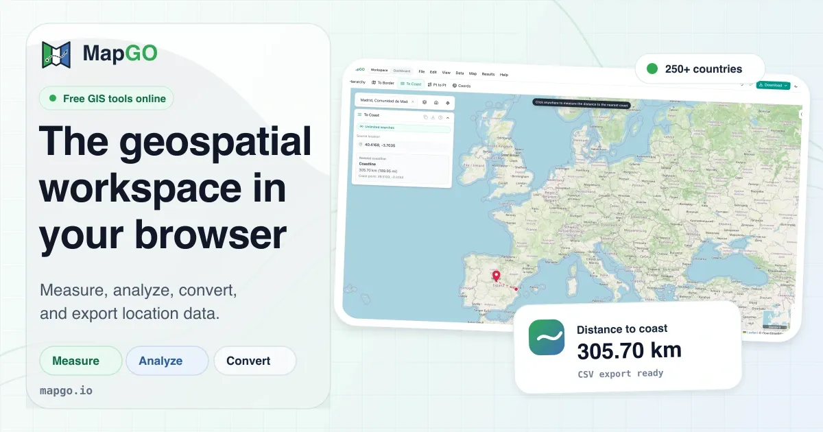
MapGO is a browser-based geospatial workspace that brings professional-grade GIS capabilities directly to the web browser. Unlike traditional desktop applications that require installation, MapGO runs entirely online, making it instantly accessible to anyone with a modern web browser. The platform offers a comprehensive set of tools for measuring distances, analyzing administrative hierarchies, converting GIS file formats, and processing bulk coordinate data. It is designed for developers, GIS analysts, surveyors, and logistics professionals who need quick answers without the overhead of heavyweight software systems.
The core value proposition is simplicity: no downloads, no setup, no complex licensing. Users can open the workspace and immediately start interacting with an interactive map. Behind the scenes, MapGO maintains a proprietary dataset of high-resolution coastline and boundary shapefiles that power its analytical features. With coverage of more than 250 countries, territories, and sub-regions, the platform promises reliable results across global contexts.
Key Features
MapGO organizes its functionality into three main pillars: analysis, measurement, and conversion. Each pillar contains a set of specialized tools that address common geospatial workflows. The platform also provides a developer API for programmatic access. Below is a detailed breakdown of what users can expect.
Geospatial Analysis Tools
The analysis suite is arguably the heart of MapGO. It delivers instant insights about any coordinate point on Earth. The underlying dataset includes administrative boundaries at multiple levels, enabling precise hierarchy lookups and distance calculations.
- Location Hierarchy: This tool returns the complete administrative path for a given coordinate, such as country → region → district → sub-region. It is invaluable for reverse geocoding, data normalization, and enriching customer records with geographical context. The results are returned quickly, and the same hierarchy is used across other features.
- Distance to Border: Calculates the great-circle distance from a point to the nearest national or regional boundary. This is useful for logistics planners determining cross-border zones, environmental agencies assessing transboundary impacts, and security teams analyzing border proximity.
- Distance to Coast: Measures the distance to the nearest coastline point. This feature is critical for maritime operations, coastal hazard assessments, real estate agents evaluating ocean proximity, and insurance underwriters calculating risk.
- Point-to-Point Distance: Users can select two arbitrary coordinates and immediately compute the straight-line distance using the great-circle formula. This tool simplifies route feasibility checks and supports navigation planning.
- GPS Converter: A built-in utility for converting coordinate formats between decimal degrees (DD), degrees-minutes-seconds (DMS), and degrees-minutes-minutes (DMM). This ensures compatibility with different GPS devices, mapping APIs, and data standards.
Measurement and Drawing Tools
MapGO transforms the interactive map into a precise measuring instrument. These tools are especially useful for field planning, site assessment, and educational purposes.
- Distance Measurement: Click anywhere on the map to define a path, and MapGO displays the cumulative distance in real time. Users can measure road segments, hiking trails, or pipeline routes without needing a separate GIS tool.
- Area Measurement: By defining a polygon with multiple points, the tool calculates the enclosed area instantly. Applications include property boundary verification, agricultural field planning, and urban block measurement.
- Radius Measurement: Select a center point and specify a radius to visualize a circular buffer. This is commonly used for identifying service delivery zones, evacuation radii, or local coverage circles.
- Bearing Measurement: Determines the compass bearing and azimuth between two points, which is essential for orienting maps, aligning structures, and planning aerial or maritime navigation.
- Buffer & Draw: Beyond basic measurement, users can create buffer zones around existing features and annotate with custom shapes such as circles, rectangles, or freeform polygons. This supports impact analysis, service-area planning, and simple cartographic compositions.
File Conversion and Bulk Processing
One of MapGO's standout capabilities is its ability to work with common GIS file formats directly in the browser. This removes the need for conversion software and speeds up data exchange.
- File Conversion: The platform supports conversion between GeoJSON, KML, GPX, Shapefile, and CSV. Users can upload a file in one format and download the result in another, preserving geometry and attributes. This interoperability is essential for integrating data from various sources or exporting to legacy systems.
- Bulk CSV Upload: For large datasets, users can upload a CSV file containing thousands of latitude/longitude pairs. MapGO processes each row, enriching it with requested attributes such as administrative hierarchy or distance-to-border values. The processed result can be downloaded as a new CSV, enabling batch geocoding and spatial enrichment.
- Load onto the Map: Users can drag and drop a GeoJSON file with arbitrary features—such as country boundaries, custom regions, or point clusters—and instantly visualize them on the interactive map. This is ideal for validation, visual inspection, and preliminary analysis before further processing.
Developer API
MapGO extends its functionality through a REST API hosted on RapidAPI. The API exposes endpoints for full location responses, combining hierarchy, border distance, and coastline distance in a single call. It is designed for developers who want to integrate geospatial intelligence into their own applications without building a database of boundaries from scratch.
Key API benefits include:
- Fast Response Times: The API is optimized for low-latency queries, making it suitable for real-time applications.
- High Availability: With a reported 99.9% uptime, it meets enterprise reliability expectations.
- Generous Free Tier: Developers can start testing immediately with a free quota, making it easy to evaluate the service before scaling up.
The API documentation includes clear usage examples, and authentication is handled via standard RapidAPI keys.
How It Works
MapGO is a fully client-side application, meaning all processing occurs in the browser. This architecture reduces server load and provides immediate interaction. The workflow is designed to be straightforward:
- Launch the Workspace: Navigate to the workspace from the homepage. The map loads instantly, and the tool panel appears on the left side.
- Choose a Tool: Each tool is represented by an icon and label. Clicking a tool activates the corresponding mode on the map. For measurement tools, the cursor changes to allow clicking points.
- Interact with the Map: Users can pan, zoom, and click directly on the map to place markers or define geometric shapes. Results are calculated on the fly and displayed in a side panel, often with formatted numerical values.
- Upload and Process Data: For data-driven workflows, users can upload CSV or GeoJSON files. The platform processes them locally and optionally sends batches to the backend for enrichment, depending on the plan.
- Download Results: After processing, users can download the enriched or converted data in the desired format. This ensures the platform fits seamlessly into existing workflows.
The user interface is clean and responsive, with tooltips and clear labels. The navigation includes a tools directory that lists all available utilities, making it easy to discover functions quickly. Additionally, the inclusion of educational games offers a low-pressure way for new users to familiarize themselves with map coordinates and spatial relationships.
Use Cases
MapGO's combination of analysis, measurement, and conversion tools addresses a wide array of real-world scenarios.
- Logistics and Fleet Management: Route planners can use point-to-point distances to estimate travel times and the distance-to-border tool to identify when shipments cross international boundaries. Bulk CSV upload simplifies processing of hundreds of stops.
- Real Estate and Property Development: Realtors and developers rely on area measurement to verify lot sizes, while the distance-to-coast tool helps market waterfront properties. Buffer zones are useful for assessing proximity to schools, parks, or retail centers.
- Environmental Monitoring: Researchers use these tools to measure distances to sensitive habitats, calculate the footprint of protected areas, and analyze the impact of coastline changes. The platform's accuracy and speed make it a convenient field instrument.
- Custom Software Development: The API allows developers to embed geospatial lookups into CRM systems, fraud detection engines, or location-based recommendation platforms. The file conversion feature also simplifies data ingestion.
- Education and Training: Geography students and educators can demonstrate concepts like great-circle distances and administrative hierarchies in a visual, interactive way. The included games make learning engaging.
- E-commerce and Delivery Services: Businesses can define delivery radii, calculate shipping distances, and determine whether addresses fall within service boundaries, all within a simple web interface.
Pricing & Value
MapGO adopts a freemium pricing model to cater to different user segments. The entry point is generous: users can perform five lookups per day without creating an account, and ten per day with a free account. This allows anyone to test core features and verify that the platform meets their needs.
For heavier users, paid plans introduce higher daily lookup quotas, access to bulk processing, and priority support. The exact pricing tiers are outlined on the pricing page. Given the breadth of features included even in the free tier, MapGO offers good value for occasional users. The RapidAPI free tier also provides developers a risk-free way to prototype integrations.
When compared to traditional GIS software licenses, MapGO's subscription model is considerably more accessible for small teams and individual professionals. It eliminates the need for on-premise installations and reduces IT overhead.
Final Verdict
MapGO successfully brings essential geospatial capabilities into the browser without sacrificing functionality. Its strength lies in its convenience: users can perform complex measurements, run hierarchical lookups, and convert files in seconds, all without leaving the web browser. The platform's dataset coverage and real-time response times make it a reliable companion for fieldwork, data analysis, and software development.
The main limitation is the restricted free tier, which may not support frequent use. However, for those who need occasional spatial answers, MapGO is an excellent free resource. For persistent needs, the paid plans are reasonably positioned to scale with demand. Organizations seeking a lightweight GIS alternative to heavyweight desktop suites will find MapGO a compelling choice. It is especially recommended for web-savvy professionals who value speed and simplicity.